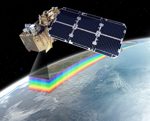
Sentinel-2 Satellite Description
Each SENTINEL-2 satellite weighs approximately 1.2 tonnes. SENTINEL-2A and SENTINEL-2B have both been launched with the European launcher VEGA.
The satellite lifespan is 7.25 years, which includes a 3 month in-orbit commissioning phase. Batteries and propellants have been provided to accommodate 12 years of operations, including end of life de-orbiting manoeuvres.
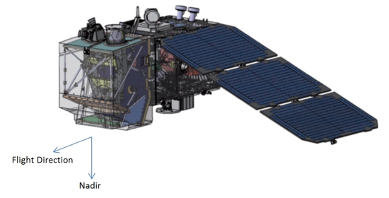
Two identical SENTINEL-2 satellites operate simultaneously, phased at 180° to each other, in a sun-synchronous orbit at a mean altitude of 786 km. The position of each SENTINEL-2 satellite in its orbit is measured by a dual-frequency Global Navigation Satellite System (GNSS) receiver. Orbital accuracy is maintained by a dedicated propulsion system.
The SENTINEL-2 satellite system was developed by an industrial consortium led by Astrium GmbH (Germany). Astrium SAS (France) is responsible for the MultiSpectral Instrument (MSI).
The MSI works passively, by collecting sunlight reflected from the Earth. New data is acquired at the instrument as the satellite moves along its orbital path. The incoming light beam is split at a filter and focused onto two separate focal plane assemblies within the instrument; one for Visible and Near-Infra-Red (VNIR) bands and one for Short Wave Infra-Red (SWIR) bands . The spectral separation of each band into individual wavelengths is accomplished by stripe filters mounted on top of the detectors.
The optical design of the MSI telescope allows for a 290 km Field Of View (FOV).
A shutter mechanism prevents the instrument from direct illumination by the sun in orbit and to avoid contamination during launch. The same mechanism functions as a calibration device by collecting the sunlight after reflection by a diffuser.
Source: https://sentinels.copernicus.eu/web/sentinel/missions/sentinel-2/satellite-description
MultiSpectral Instrument (MSI)
The MultiSpectral Instrument (MSI) uses a push-broom concept. A push-broom sensor works by collecting rows of image data across the orbital swath and utilises the forward motion of the spacecraft along the path of the orbit to provide new rows for acquisition. The average period of observation over land and coastal areas is approximately 17 minutes and the maximum period of observation is 32 minutes.
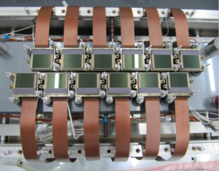
Light reflected up to the MSI instrument from the Earth and its atmosphere is collected by a three-mirror (M1, M2 and M3) telescope and focused, via a beam-splitter, onto two Focal Plane Assemblies (FPAs): one for the ten VNIR wavelengths and one for the three SWIR wavelengths.
Radiometric calibration of the MSI instrument is achieved via a diffuser fitted on the inside face of the combined Calibration and Shutter Mechanism (CSM).
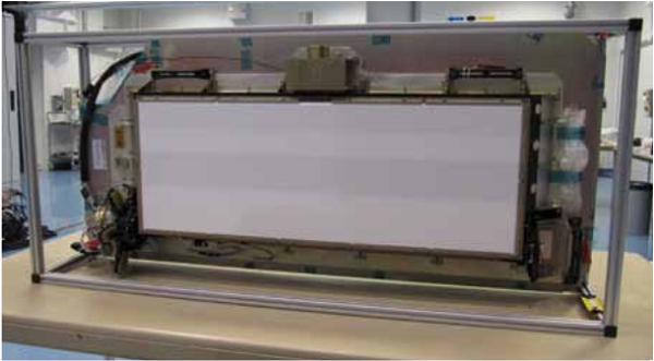
To achieve the required 290 km swath width, both the VNIR and SWIR FPAs are composed of 12 detectors, staggered in two horizontal rows. Further separation of the individual VNIR and SWIR bands is achieved using stripe filters overlaying the detectors. The VNIR Focal Plane is shown.
Source: https://sentinels.copernicus.eu/web/sentinel/missions/sentinel-2/instrument-payload
Resolution and Swath
Spatial and Spectral Resolutions
The surface area measured on the ground and represented by an individual pixel, is termed as the spatial resolution. For Sentinel-2, there are three possible spatial resolutions (see table).
Spectral resolution is defined as a measure of ability to resolve features in the electromagnetic spectrum. Sentinel-2 spectral resolutions (Bandwidth) are provided in the table.
NOTE: The Bandwidth (nm) is measured at Full Width Half Maximum (FWHM).
| Spatial Resolution (m) | Band Number | S2A Central Wavelength (nm) | S2A Bandwidth (nm) | S2B Central Wavelength (nm) | S2B Bandwidth (nm) |
| 10 | 2 | 492.4 | 66 | 492.1 | 66 |
| 10 | 3 | 559.8 | 36 | 559 | 36 |
| 10 | 4 | 664.6 | 31 | 664.9 | 31 |
| 10 | 8 | 832.8 | 106 | 832.9 | 106 |
| 20 | 5 | 704.1 | 15 | 703.8 | 16 |
| 20 | 6 | 740.5 | 15 | 739.1 | 15 |
| 20 | 7 | 782.8 | 20 | 779.7 | 20 |
| 20 | 8a | 864.7 | 21 | 864 | 22 |
| 20 | 11 | 1613.7 | 91 | 1610.4 | 94 |
| 20 | 12 | 2202.4 | 175 | 2185.7 | 185 |
| 60 | 1 | 442.7 | 21 | 442.2 | 21 |
| 60 | 9 | 945.1 | 20 | 943.2 | 21 |
| 60 | 10 | 1373.5 | 31 | 1376.9 | 30 |
Radiometric Resolution
Radiometric resolution is a measure of the ability of an imaging system to record different levels of brightness or tone. The radiometric resolution of Sentinel-2 is 12-bit. This gives a potential range of brightness levels from 0 – 4 095.
Note: More information on Spatial and Radiometric Resolutions used in Sentinel-2 Mission
Temporal Resolution
Temporal resolution is the amount of time, expressed in days, that elapses before a satellite revisits a particular point on the Earth’s surface. The satellites in the Sentinel-2 constellation will provide a revisit time of five days at the equator in cloud-free conditions.
Swath Width
The swath width of Sentinel-2 is 290 km. In comparison, the swath width of Landsat 5 TM and Landsat 7 ETM+ is 185 km, and the swath width of SPOT-5 is 120 km.
Orbit
The Sentinel-2 mission orbit is sun-synchronous. Sun-synchronous orbits are used to ensure the angle of sunlight upon the Earth’s surface is consistently maintained. Apart from small seasonal variations, anchoring of the satellites orbit to the angle of the sun minimises the potential impact of shadows and levels of illumination on the ground. This ensures consistency over time and is critical in assessing time-series data.
Sentinel-2A and Sentinel-2B occupy the same orbit, but separated by 180 degrees.The mean orbital altitude is 786 km. The orbit inclination is 98.62° and the Mean Local Solar Time (MLST) at the descending node is 10:30 (am). This value of MLST was chosen as a compromise between a suitable level of solar illumination and the minimisation of potential cloud cover. The MLST value is close to the local overpass time of Landsat and almost identical to that of SPOT-5, permitting the integration of Sentinel-2 data with existing and historical missions, and contributing to long-term time series data collection.
The following table contains a summary of useful orbital information for Sentinel-2A and –2B:
| Altitude | Inclination | Period | Cycle | Ground-track deviation | Local Time at Descending Node |
| 786 km | 98.62 deg | 100.6 min | 10 days | +- 2 km | 10:30 hours |
The KML data file informing on the position of the Sentinel-2A and Sentinel-2B Relative Orbits for a full Cycle (143 Orbits) with a time step of 10 seconds is available:
Source: https://sentinels.copernicus.eu/web/sentinel/missions/sentinel-2/satellite-description/orbit

 https://sentinels.copernicus.eu/
 https://sentinels.copernicus.eu/

 https://sentinels.copernicus.eu/
Leave a Reply
Want to join the discussion?Feel free to contribute!