Sentinel-2 Ground Segment
The ground segment is composed of the Core Ground Segment, the Collaborative Ground Segment and the Copernicus contributing missions’ ground segments.
The core ground segment monitors and controls the SENTINEL spacecraft, ensures the measurement data acquisition, processing, archiving and dissemination to the final users. In addition, it is responsible for performing conflict-free mission planning according to a pre-defined operational scenario, and ensures the quality of data products and performance of the space-borne sensors by continuous monitoring, calibration and validation activities, guaranteeing the overall performance of the mission.
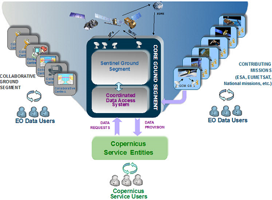
The Copernicus ground segment is complemented by the SENTINEL collaborative ground segment, which was introduced with the aim of exploiting the SENTINEL missions further. This entails additional elements for specialised solutions in different technological areas such as data acquisition, complementary production and dissemination, innovative tools and applications, and complementary support to calibration and validation activities.
The Copernicus contributing mission ground segments, with their own specific control functions, data reception, data processing, data dissemination and data archiving facilities, deliver essential data complementing the SENTINEL missions.
Source: https://sentinels.copernicus.eu/web/sentinel/missions/sentinel-2/ground-segment
Core Ground Segment
The SENTINEL core ground segment allows all SENTINEL data to be systematically acquired, processed and distributed. It includes elements for monitoring and controlling the SENTINEL satellites and for downloading, processing and disseminating the data to users. It also has mechanisms for monitoring and controlling the quality of data products, as well as for data archiving. Infrastructure is ‘distributed’, meaning that various centres are in different locations but linked together and coordinated. Despite the complexity of the system, users are offered a single virtual access point for locating and downloading products.
The main facilities of the SENTINEL core ground segment are:
- The Flight Operations Segment (FOS) – responsible for all flight operations of the SENTINEL satellites, including monitoring and control, execution of all platform activities and commanding of the payload schedules.
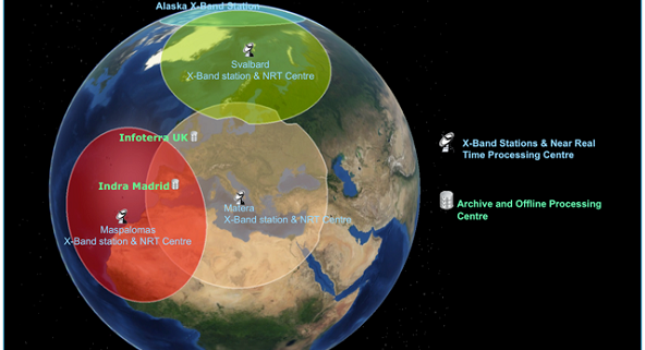
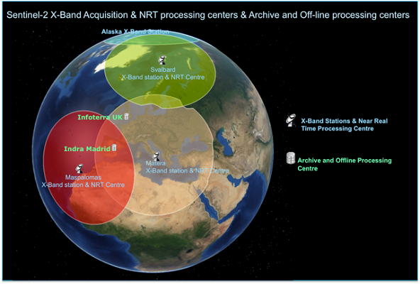
- The Core Ground Stations (CGS) – where the SENTINEL data are downlinked and products are generated in near real-time. A network of X-band ground stations allows the downlink of all SENTINEL data. These are complemented by utilisation of the European Data Relay Satellite (EDRS) for additional downlink of SENTINEL data to EDRS ground stations.
- The Processing and Archiving Centre’s (PACs) – where systematic non-time critical data processing is performed. All data products are archived for online access by users. A network of PACs supports all processing and archiving of SENTINEL data.
- The Mission Performance Centres (MPCs) – responsible for calibration, validation, quality control and end-to-end system performance assessment. The MPCs include expert teams for specific calibration/validation, off-line quality control, algorithm correction and evolution activities.
- The SENTINEL Precise Orbit Determination (POD) facility – makes use of the GNSS receiver data on the SENTINELS to deliver the orbital information needed to generate data products.
- The Copernicus Space Component Wide Area Network (CSC WAN) – allows all products and auxiliary data to be carried across the various ground segment facilities and provides disseminated data products to end users.
All SENTINEL data are systematically processed up to the designated level and according to different timelines, ranging from near real-time to non-time critical, available typically within 3-24 hours of being sensed by the satellite.
Source: https://sentinels.copernicus.eu/web/sentinel/missions/sentinel-2/ground-segment/core-ground-segment
Payload Data Ground Segment (PDGS)
The Payload Data Ground Segment (PDGS) is responsible for exploitation of the instrument data. The PDGS is operated from ESA’s Centre for Earth Observation also known as the European Space Research Institute (ESRIN) in Frascati, Italy. The PDGS operationally generates the user products and distributes processed Level-1C and Level-2A products.
The PDGS includes the facilities responsible for mission control (mission planning, production planning), quality control (calibration, validation, quality monitoring, instrument performance assessment), precise orbit determination, user services interface and acquisition, processing and archiving.
Real-time sensed data as well as data played back from on-board saved data are downlinked directly to ground or via the European Data Relay Satellite (EDRS), received, down-converted, demodulated and transferred to the processing facilities for systematic generation and archiving of Level-0 and Level-1/2 data products.
The PDGS is expected to receive and process 2.4 TBytes of compressed raw data per day for the two satellites in addition to data from all other ESA missions. MSI Level-0 data are processed to produce Level-1 and Level-2 products applying all the necessary processing algorithms and formatting techniques.
The PDGS is distributed over several core centres including Core Ground Stations (CGS), Processing and Archiving Centres (PAC), Mission Performance Centres (MPC) and Precise Orbit Determination (POD) facilities.
Core Ground Stations – the network of X-band core ground stations located in Alaska, USA, Matera, Italy, Maspalomas, Spain and Svalbard, Norway, are responsible for data acquisition and near real-time processing.
Processing and Archiving Centres – PACs perform long-term data archiving, data access and systematic non-time critical data processing. Archiving and long-term preservation of data is ensured for all Level-0 data and for a set of configurable systematic higher level products.
Mission Performance Centres – MPCs are responsible for calibration, validation, quality control and end-to-end system performance assessment. The MPCs include expert teams for specific cal/val, off-line quality control and algorithm correction activities.
Precise Orbit Determination – POD facilities make use of the GNSS receiver data on-board the SENTINEL satellites to deliver the orbital information needed for generation of mission products.
Coordination between the centres is provided through the Payload Data Management Centre (PDMC) at ESRIN in Frascati, Italy.
SENTINEL-2 products are provided to the user through online access. Near real-time dissemination is allocated to the receiving stations and less time-critical data dissemination is allocated to the assembly, processing and archiving centres.
CPOD Service
The Copernicus POD (Precise Orbit Determination) Service is part of the Copernicus PDGS Ground Segment of the Sentinel missions and is in charge of the provision of Precise Orbital Products and auxiliary data files to the PDGS. The Copernicus POD Service was developed and is being operated by a GMV-led consortium from Tres Cantos, Spain. Additionally, for Sentinel-3 there is a POD Instrument Processing Facility in charge of generating the Near Real Time products running directly at the S-3 PDGS facilities.
This web page contains basic information describing the CPOD Service. Moreover, the CPOD Service regularly provides dynamic content for users who want to use the POD Orbital Products. This information can be found under the Technical Guides section.
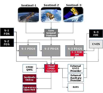
The Copernicus POD Service interacts with many different entities, internal and external to the Copernicus program. The following is a description of the main elements involved in the Copernicus POD Service:
GMV: leader of the consortium in charge of running the Copernicus POD Service. GMV is responsible for the proper function of the CPOD Service, including the generation and delivery of all precise orbital products and auxiliary date meeting accuracy and timeliness requirements, together with the coordination activities between the different elements that interact with the CPOD Service.
Payload Data Ground Segment (PDGS): The PDGS is the main provider of inputs to the CPOD Service (GNSS measurements, attitude information, etc) and the unique recipient of the products generated.
Sentinels Flight Operations Segment (FOS): Located at ESOC for Sentinel-1, Sentinel-2 and Sentinel-3 (for Sentinel-3 only during the commissioning phase) and EUMETSAT for Sentinel-3 during the routine operation phase, it is the provider of operational orbits, manoeuvre information and the satellite mass and centre of gravity evolution.
External GNSS data Provider (EGP): A dedicated high accuracy and reliability external GPS data provider (VERIPOS). High rate orbits and clocks are provided with different levels of timeliness and accuracy. In case of unavailability a back-up solution has been put in place based on magicGNSS, a GMV solution for GNSS accurate products. IGS final orbits and clocks are also retrieved and used in the computation of the NTC products.
International Laser Ranging Service (ILRS): They provide Sentinel-3 SLR data to be used in the POD processing, while the Copernicus POD provides orbit predictions (CPF files) of Sentinel-3 to ILRS.
External Auxiliary providers: Earth Orientation Parameters and leap seconds from IERS (International Earth Rotation Service), solar and magnetic activity information for geodesy computations from NOAA and atmospheric gravity models from NASA.
Centre National d’Études Spatiales (CNES): They provide Sentinel-3 orbital and attitude products (for comparison purposes), together with DORIS data. Copernicus POD provides GNSS Observation RINEX files to CNES.
External Validation: A number of independent institutions (ESOC, DLR, TUM, AIUB and TU Delft) provide independent orbit solutions for validation purposes to assess the quality of the CPOD products. For Sentinel-3 other centres will provide orbital products, including CNES and EUMETSAT.
CPOD Quality Working Group (CPOD QWG): The main purpose is to monitor the performance of the operational POD products (both the orbit products as well as the input tracking data) and to define potential and future enhancements to the orbit solutions.
Source: https://sentinels.copernicus.eu/web/sentinel/missions/sentinel-2/ground-segment/cpod
CPOD QWG
The Copernicus POD Quality Working Group (CPOD QWG) is a dedicated group of experts in Precise Orbit Determination who provide independent POD solutions, allowing to carry out external validation of the operational POD products. Additionally, they perform analysis to monitor the quality of the input tracking data, conduct research on improved models and algorithms and define potential and future enhancements to the orbit solutions. The members of the CPOD QWG meet usually twice a year to present the main findings since the previous meeting and to decide on which aspects are worth investigating in the near future.
The main tasks of the CPOD QWG can be summarised as follows:
- Gather information: Through attending conferences and interactions with the IDS Analysis Working Group, the Copernicus POD QWG gathers information on any potential algorithm evolution that could benefit the Copernicus POD system. Besides, the interaction with the international services of all observation techniques available for the Sentinels (IGS, IDS and ILRS) is maintained. The IERS conventions and realisations of the ITRF are updated. The evolution of the (CNES) GDR standards is also considered.
- Evaluate: Evolutions are evaluated on a separate validation with at least other POD centre (CNES; ESOC). Quality indicators evaluated are orbit overlap, tracking data residuals, the magnitude of the empirical accelerations, external orbit comparison, and in the case of Sentinel-3, altimeter crossover performance.
- Make recommendations: The most promising enhancements are presented and discussed during the QWG meetings.
- Implement changes: After the internal and external evaluation and approval of ESA the algorithm evolution is included in the next upgrade of the POD.
- Membership: The composition of the Copernicus POD QWG is composed by representatives of ESA, EUMETSAT, CNES, NASA, GMV, POSITIM, DLR, TUM, AIUB, TU Delft, DGFI, GFZ, CLS, Sentinel-3 Validation Team Meeting, the Mission Performance Centre of each Sentinel, Payload Data Ground Segment of each mission, the Copernicus Service and the Post-Launch Support Office.
The main analysis presented and conclusions reached in each CPOD QWG meeting, held twice a year, are included in the S2 POD Document Library.
Source: https://sentinels.copernicus.eu/web/sentinel/missions/sentinel-2/ground-segment/cpod/cpod-qwg
Flight Operations Segment (FOS)
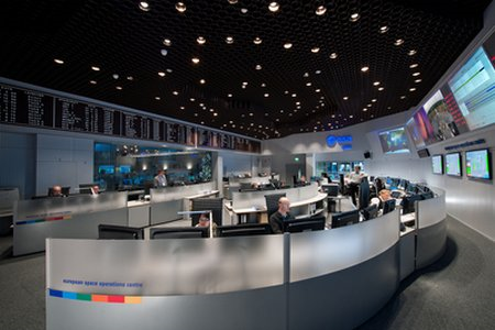
The Flight Operation Segment (FOS) is responsible for command and control of the satellite and is operated from ESA’s European Space Operations Centre (ESOC) in Darmstadt, Germany.
The FOS consists of the Ground Station and Communications Network, Flight Operations Control Centre and a General Purpose Communication Network.
The FOS provides the capability to monitor and control the satellite during all mission phases including the Flight Dynamics System facility responsible for orbit determination and prediction, and for the generation of attitude and orbit control telecommands.
The main functions of the FOS include:
Mission planning
Long term planning of spacecraft and payload activities, covering the complete orbit cycle and repeating indefinitely. Short term planning, nominally every 2 weeks, in the form of updated mission schedules.
Spacecraft status monitoring
Processing housekeeping telemetry, providing information about the status of all spacecraft subsystems and attitude.
Spacecraft control
Taking control actions by means of telecommands, based on the spacecraft monitoring and following the mission plan.
Orbit determination and control
Using tracking data and implementing orbit manoeuvres, ensuring required orbital conditions are achieved.
Attitude determination and control
Using processed attitude sensor data from spacecraft monitoring and by commanded updates of control parameters through the on-board attitude control system.
On-board software maintenance
Integrating software images received from the spacecraft manufacturer (pre-launch and post-launch) into the telecommand process.
Communications
Communicating (TM/TC) with one satellite at a time.
 https://sentinels.copernicus.eu/
 https://sentinels.copernicus.eu/